Last updated: 2026-04-02
- The Old Town panorama loop — about two hours on the water — runs Gruž → Fort Lovrijenac → the seaward walls → Old Port → Banje → Lokrum channel and back.
- The walls rise up to 25 m straight from the rock — a view you cannot get on foot.
- Best light: 09:00–10:00 on Lovrijenac, golden hour on the walls.
- Charters from €730 per boat (4 h on the Catamaran X, up to 12 guests), skipper, insurance and safety equipment included.
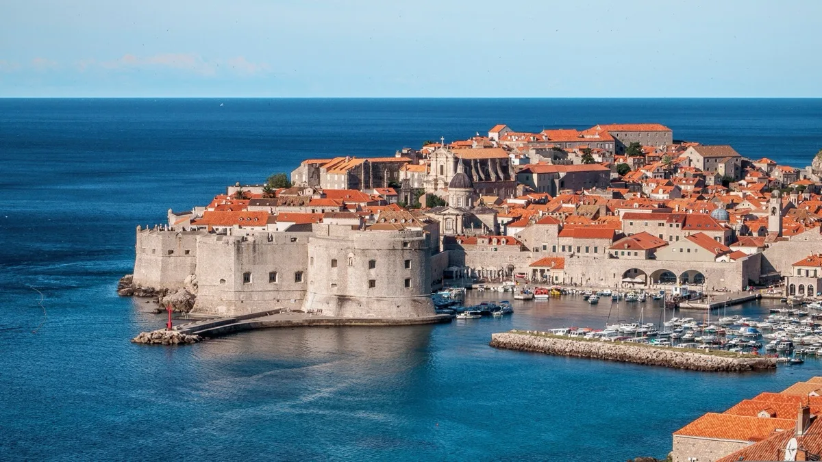
Most visitors see the Old Town from Stradun, from the wall walk, or from the cable car up Srđ. Almost nobody sees it the way it was designed to be seen: from a boat, at deck height, the way every merchant, admiral and invader saw it for 500 years. This post walks you through exactly what appears off the bow on our 2-hour panorama route — and when to go for the best photographs.
What do you actually see from the water?
From the sea you see the whole defensive logic of the city at once: a ring of stone dropped straight onto the cliff line, with no beach, no landing point and no soft edge anywhere. The Walls of Dubrovnik run 1,940 m around the Old Town and reach roughly 25 m in height; the seaward sections sit directly on limestone that falls away into 10–20 m of clear water. From land you walk on top of them. From the water you look up at them, which is a very different experience.
You also see things the land route hides entirely. The small chapel of Our Lady of Danče on its headland. The sea caves under the wall at Kolorina bay. The rock shelf below Buža bar, with swimmers dropping into deep blue. And the Old Port entrance — two moles, the Porporela breakwater, and St John’s Fort guarding the gap — which reads as a working harbour from sea level and as a postcard from everywhere else.
How did the walls end up facing the sea?
Because the sea was where the threat came from. The city was a maritime republic — Ragusa — from 1358 to 1808, and its wealth travelled by ship, so the fortifications were built to answer naval attack first. Most of what stands today was raised or thickened in the 15th and 16th centuries, when artillery changed siege warfare. The landward walls are up to 6 m thick; the seaward walls are thinner, 1.5–3 m, because the architects trusted the cliffs to do half the work.
Just outside the circuit stands Fort Lovrijenac, a triangular fortress on a 37 m sea rock west of the walls. Above its gate is the inscription the city still quotes: Non bene pro toto libertas venditur auro — “liberty is not sold for all the gold in the world”. From the water, Lovrijenac and the Bokar bastion frame a narrow channel of sea between them; sailing through that gap is the single most photographed moment of the route.
Where are the best photo angles?
The best angles are the three the footpaths cannot reach. Our skippers position the boat for each one and cut the engine so you can shoot without vibration.
- The Lovrijenac gap. Sitting in Kolorina bay, between the fortress and the Bokar bastion, you get cliff, fort and wall stacked in one frame. Shoot wide, from as low as you can.
- The full seaward face. About 300 m off the walls, between Buža and St John’s Fort, the entire southern circuit fits in a single shot with Srđ rising behind it. This is the classic panorama.
- The Old Port entrance. Nose-on to the gap between the Porporela and the mole, with fishing boats and the clock tower behind. Best with a slightly longer lens.
A bonus fourth: from the Lokrum channel looking back, the Old Town sits low on the water with Banje beach in front of it — the angle most drone shots imitate.
When is the best time of day to go?
Morning departures around 09:00–10:00 give the most reliable light. The sun is high enough to bring the sea to full colour but still angled, so Lovrijenac and the western walls are lit rather than silhouetted, and the water in the coves reads turquoise on camera. Midday is harsher on the stone but gives the deepest blues for swimming photographs. Late afternoon is the romantic option: from about two hours before sunset the walls turn from grey to honey to gold — that is the window our sunset champagne cruise is built around.
Sea state matters as much as light. The prevailing summer maestral builds from the northwest after midday, so mornings are usually the calmest ride and the sharpest photographs. The Dubrovnik Tourist Board events calendar is also worth a glance — during the Summer Festival in July and August, flags fly from Lovrijenac and the forts, which looks superb from the water.
What does the 2-hour route look like?
Here is the route in words, as we actually run it. Times assume a 10:00 departure.
| Time | Leg | What you see |
|---|---|---|
| 10:00 | Depart Gruž Harbour | Working port, Lapad peninsula |
| 10:15 | Round Cape Petka | Daksa islet, open Adriatic |
| 10:30 | Danče and Kolorina | Chapel headland, Fort Lovrijenac gap — photo stop |
| 10:45 | Along the seaward walls | Full southern circuit, Buža, sea caves |
| 11:00 | Old Port entrance | Porporela, St John’s Fort, clock tower |
| 11:15 | Banje and the Lokrum channel | Beach panorama, Lokrum’s pine cliffs |
| 11:35 | Optional swim stop | Calm cove by Lokrum, weather permitting |
| 12:00 | Return to Gruž | Coffee on the way in |
The pace is deliberately slow — this is a panorama, not a transfer. If your group would rather trade the swim stop for more time drifting under the walls, tell the skipper; it is your boat for the morning.
How do you book it?
The panorama loop runs on any of our eight yachts — from €730 per boat for a four-hour charter on the Catamaran X (up to 12 guests), with skipper, insurance and safety equipment included — full details on the Old Town boat tour page. You can check dates and reserve online in about two minutes at our booking page, and four hours is enough for the walls and an island in one outing. Either way, bring a camera with a charged battery. You will use all of it.
By Captain Marko Radić — twenty seasons on this stretch of the Adriatic, and the walls still get him every time.